Log in
All resources
Create a design
372 Free Artworks of British Empire
british library
copper engraving print
joan blaeu
1667 maps
a map of the british empire in america with the french and spanish settlements adjacent thereto
british museum
17th-century maps of the spanish empire
atlas maior, vol 11 (asia) - joan blaeu, 1667 - bl 114.h(star).11
novus atlas sinensis
maps with figures
a map of the british empire in america with the french and spanish settlements adjacent thereto
bibliothèque nationale de france
a map of the british empire in america with the french and spanish settlements adjacent thereto
bibliothèque nationale de france
a map of the british empire in america with the french and spanish settlements adjacent thereto
bibliothèque nationale de france
book illustrations in the british museum
prints by tobias stimmer
a map of the british empire in america with the french and spanish settlements adjacent thereto
1730s maps of the caribbean
khamsa of nizami, british library, or. 2265
mirza ali
drawings by gentile bellini
sitting women in art
a map of the british empire in america with the french and spanish settlements adjacent thereto
1730s maps of the caribbean
ghosts & ghoulish scenes
atlas maior, vol 11 (asia) - joan blaeu, 1667 - bl 114.h(star).11
1667 maps
benjamin wilson
1901 books
maps of the history of the united states
old maps of the british empire
beirut in the 19th century
alexandria in the 1870s
atlas maior, vol 11 (asia) - joan blaeu, 1667 - bl 114.h(star).11
17th-century maps of korea
a map of the british empire in america with the french and spanish settlements adjacent thereto
1730s maps of the caribbean
paintings by ozias humphrey
portraits of jane austen
a map of the british empire in america with the french and spanish settlements adjacent thereto
1730s maps of central america
19th-century maps of the ottoman empire
maps in the british museum
jahangir weighing prince khurram against gold and silver
weighing scale
east prospect of the city of philadelphia
philadelphia in the 1760s
aquatint prints in the yale center for british art
william daniell
caricatures by georges ferdinand bigot
japonisme
atlas maior, vol 11 (asia) - joan blaeu, 1667 - bl 114.h(star).11
1667 maps
atlas maior, vol 11 (asia) - joan blaeu, 1667 - bl 114.h(star).11
1667 maps
prints in the national army museum (united kingdom)
edmund walker (artist)
1909 cartoons
john bull
1909 cartoons
john bull
1730s maps of south carolina
old maps of north america
atlas maior, vol 11 (asia) - joan blaeu, 1667 - bl 114.h(star).11
1667 maps
atlas maior, vol 11 (asia) - joan blaeu, 1667 - bl 114.h(star).11
1667 maps
19th-century portrait paintings in the princeton university art museum
american portrait paintings in the princeton university art museum
corps of royal artillery drivers
charles hamilton smith
the web of empire - a diary of the imperial tour of their royal highnesses the duke and duchess of cornwall and york in 1901 (1902)
1901 royal tour of new zealand by duke and duchess of cornwall and york
1869 stamps of natal
chalon head
drawings by gentile bellini
sitting women in art
maps in the british museum
1610s maps of ireland
sennacherib
nimrud
corps of royal artillery drivers
charles hamilton smith
herbert james draper
classicism
atlas maior, vol 11 (asia) - joan blaeu, 1667 - bl 114.h(star).11
1667 maps
maps in the british museum
maps by john speed
atlas maior, vol 11 (asia) - joan blaeu, 1667 - bl 114.h(star).11
1667 maps
atlas maior, vol 11 (asia) - joan blaeu, 1667 - bl 114.h(star).11
1667 maps
atlas maior, vol 4 (netherlands) - joan blaeu, 1667 - bl 114.h(star).4
1667 maps
a map of the british empire in america with the french and spanish settlements adjacent thereto
maps in the library of congress
coloured lithographs in the british museum
josef lanzedelli der jüngere
atlas maior, vol 12 (america) - joan blaeu, 1667 - bl 114.h(star).12
1667 maps
1877 paintings
édouard adam
atlas maior, vol 12 (america) - joan blaeu, 1667 - bl 114.h(star).12
1667 maps
atlas maior, vol 12 (america) - joan blaeu, 1667 - bl 114.h(star).12
1667 maps
london printing and publishing company ltd.
john rogers (engraver)
surcharges on stamps of the british empire
1880 stamps of the cape of good hope
drawings in the yale center for british art
paintings by william hodges
michael angelo hayes
charles henry jeens
drawings in the yale center for british art
william hodges
military history of the mughal empire
baburnama, british museum
drawings in the yale center for british art
paintings by william hodges
drawings in the yale center for british art
paintings by william hodges
a map of the british empire in america with the french and spanish settlements adjacent thereto
maps in the library of congress
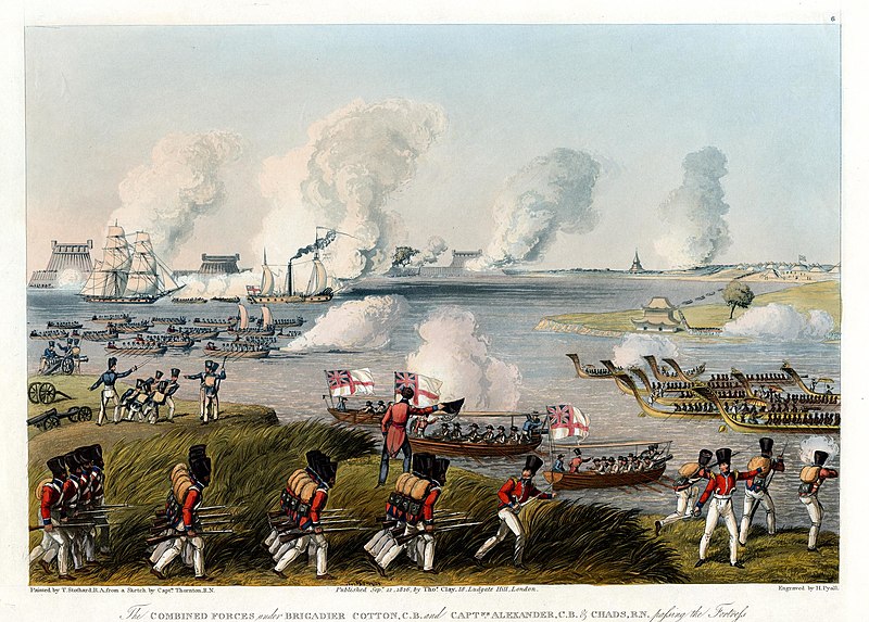
uss wasp and hms frolic by thomas birch
naval flags of the united states in art
a map of the british empire in america with the french and spanish settlements adjacent thereto
maps in the library of congress
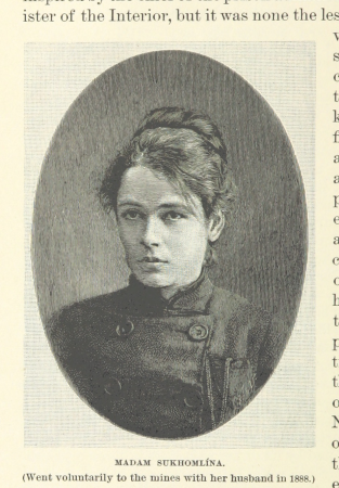
women of the world from the british library mechanical curator collection
siberia in the 19th century
a map of the british empire in america with the french and spanish settlements adjacent thereto
maps in the library of congress
a map of the british empire in america with the french and spanish settlements adjacent thereto
maps in the library of congress
the indian empire - its history, topography, government, finance, etc. (1858)
robert melville grindlay
a map of the british empire in america with the french and spanish settlements adjacent thereto
maps in the library of congress
atlas maior, vol 12 (america) - joan blaeu, 1667 - bl 114.h(star).12
1667 maps
atlas maior, vol 12 (america) - joan blaeu, 1667 - bl 114.h(star).12
1667 maps
atlas maior, vol 12 (america) - joan blaeu, 1667 - bl 114.h(star).12
1667 maps
prints in the national army museum (united kingdom)
edmund walker (artist)
joseph keppler's puck covers
boxing gloves in art
atlas maior, vol 11 (asia) - joan blaeu, 1667 - bl 114.h(star).11
1667 maps
atlas maior, vol 9 (italy) - joan blaeu, 1667 - bl 114.h(star).9
1667 maps of italy
the indian empire - its history, topography, government, finance, etc. (1858)
robert james elliot (royal navy)
paintings of ships by antonio jacobsen
rotterdam (ship, 1878)
joseph keppler's puck covers
boxing gloves in art
athens in the 18th century
parthenon in art
17th-century maps of cornwall
maps in the british museum
19th-century men of afghanistan
history of afghanistan in art
atlas maior, vol 9 (italy) - joan blaeu, 1667 - bl 114.h(star).9
1667 maps of italy
1880s political cartoons of the united states
joseph keppler's puck covers
a map of the british empire in america with the french and spanish settlements adjacent thereto
maps in the library of congress
a map of the british empire in america with the french and spanish settlements adjacent thereto
maps in the library of congress
military history of the british empire
j. r. skelton
the web of empire - a diary of the imperial tour of their royal highnesses the duke and duchess of cornwall and york in 1901 (1902)
first nations in british columbia
19th-century sailing ships in paintings
édouard adam
ottoman sultans in art
suleiman i
atlas maior, vol 12 (america) - joan blaeu, 1667 - bl 114.h(star).12
1667 maps of north america
drawings in the yale center for british art
paintings by william hodges
pre-raphaelite brotherhood,etruscan school,aestheticism,neoclassicism,symbolism
portraits from the british library mechanical curator collection
18th-century people of paris
1799 in paris
royal
uk
caricatures of charles stewart parnell
cartoons by joseph keppler
maps by macdonald gill
royal mail
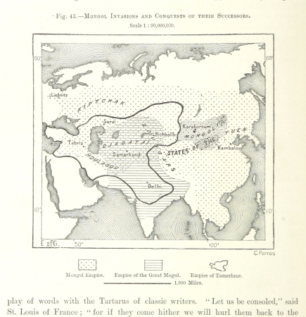
maps from the earth and its inhabitants, vol. vii
maps of the mongol empire
works by julian ashton
heidelberg school
1880s political cartoons of the united states
joseph keppler's puck covers
thomas stothard
henry pyall
atlas maior, vol 12 (america) - joan blaeu, 1667 - bl 114.h(star).12
1667 maps
copies of washington at the battle of princeton (c.w. peale, 1779)
american paintings in the chazen museum of art
201 - 300 of 372
Next page
/ 4